
I bestræbelserne på at kortlægge havbunden er undervandsafstandssensorer afgørende, da de gør det muligt at opnå detaljerede og nøjagtige kort over havbunden. De er vigtige i forbindelse med mange anvendelser såsom videnskabelig forskning, udforskning af offshore-ressourcer og andet.
Nøjagtig dybde- og afstandsmåling
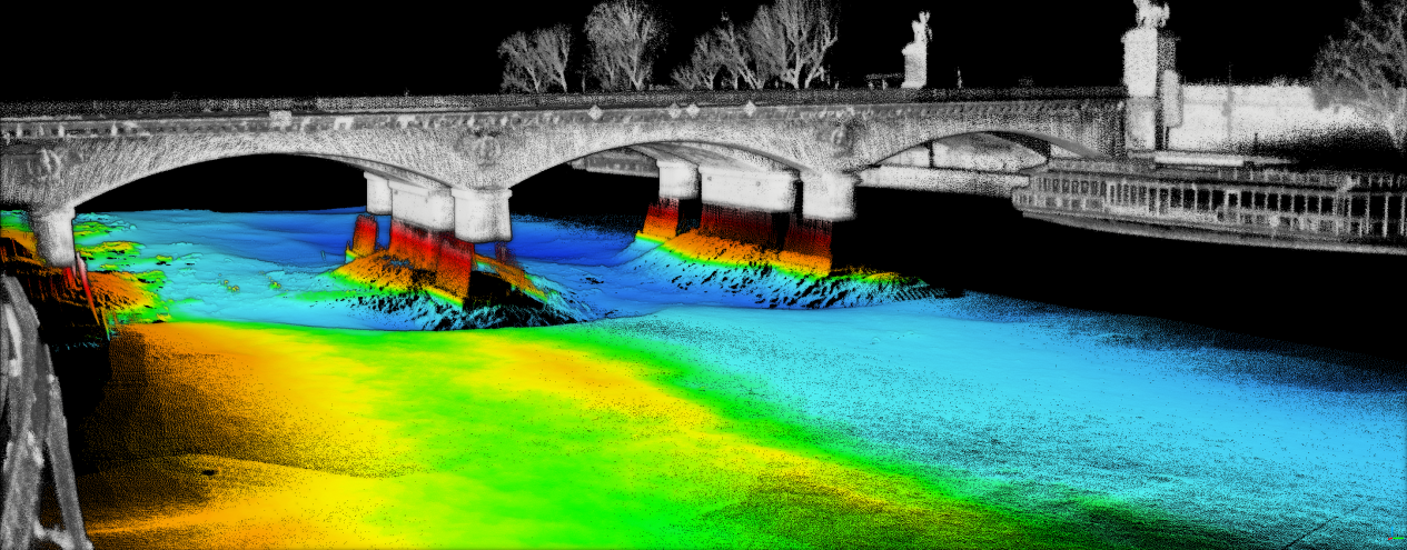
Hastigheds- og dybde/afstandsdater er kerneelementer i anvendelser til kortlægning af havbunden. Afstandssensorer (typisk akustiske højdemålere) er vigtige under vandoverfladen. Disse er pulsede lydsensorer, da de udsender lydpulser og måler den tid, det tager for ekkoet at reflekteres fra bunden. Ved brug af den kendte lydhastighed i vand kan afstanden mellem sensoren og havbunden nøjagtigt bestemmes. Kun en sådan præcision gør det muligt at tegne detaljerede batyometriske kort, der viser havbundens topografi. Kortene anvendes til at forstå oceaniske processer, herunder strømning af dybhavstrømme samt dannelsen af under vands bjerge og dale.
Navigering i komplekst terræn på havbunden
Bunden er kompleks og generelt en kantet terrænform med stejle skråninger mod dybere kløfter. Afstandssensorer under vand er også nyttige til at navigere i dette terræn. De kan levere sanntids afstandsinformation, når de er monteret på autonome undervandsfartøjer (AUV'er) eller fjernstyrede undervandsfartøjer (ROV'er). Dette gør det muligt for fartøjerne at holde en sikker afstand til havbunden for at undgå kollisioner under kortlægning. Ud over at sikre udstyret giver det mulighed for at indsamle stabile og konsekvente data over et bredt udvalg af havbundslandskaber.
Supplerer andre kortlægningsteknologier
Der anvendes typisk mange teknologier i procedurer til kortlægning af havbunden; under vands afstandssensorer bruges i kombination med andre teknologier. Afstandssensorer, som dem der bruges på hydrofoner, kan give dybdedata på overfladeniveau, f.eks. kombineret med sub-bunds profiler, som bruger lydbølger til at undersøge under havbunden og afbilde de geologiske lag. Denne kombinerede teknik giver et komplet billede af marinehavbunden, fra overfladefeatures ned til geologiske strukturer. Desuden kan afstandssensorer anvendes til kalibrering af synsfeltet og skalaen for billeder taget med under vandskameraer eller imaging-sonarer. De giver den baggrund, hvorigennem man kan fortolke de rumlige relationer mellem objekterne, der observeres på billederne, og den samlede topografi af bunden.
Modstår barske undervandsforhold
Undervandsomgivelser, som projekter og programmer såsom havbundsafbildning arbejder i, er kendt for at have et miljø med højt tryk, korroderende saltvand og ofte variable forhold. Afstandssensorer til brug under vand er konstrueret til at modstå sådanne miljøer. Denne stabilitet gør det endda muligt at anvende sensorerne i mere ekstreme dybhavsområder, ideelt set under kortlægningsflyvninger over længere tidsperioder. Dette betyder, at de kan klare vanskelige situationer, hvilket giver mulighed for konsekvent dataindsamling – noget der er af største vigtighed for produktionen af realistiske og ajourførte data til havbundskort.
Projekter inden for kortlægning af havbunden kan ikke gennemføres uden undervandsafstandssensorer. Deres evne til at foretage nøjagtige dybde- og rækkeviddeestimater, navigere gennem komplekse terræner og supplere andre kortlægningsteknologier samt deres kapacitet til at modstå de hårde betingelser i det marine miljø er grunden til, at de er blevet centrale i den nuværende indsats for at kortlægge bunden af verdenshavene.